

Kenya, located in East Africa, is a country renowned for its diverse geography, ranging from tropical coastal plains to cool highlands, vast savannas, and the dramatic Great Rift Valley. With its rich variety of landscapes, Kenya’s geography plays a pivotal role in the country’s natural beauty, agricultural productivity, and biodiversity.
Geographic Location and Area
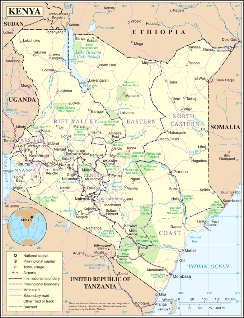
Kenya sits on the eastern edge of Africa, bordered by the Indian Ocean to the southeast. The country is located between 1°00′N latitude and 38°00′E longitude, with a total area of 580,367 km² (224,081 sq mi), making it the 48th largest country in the world. It shares borders with Ethiopia to the north, South Sudan to the northwest, Uganda to the west, Tanzania to the south, and Somalia to the east. Additionally, Kenya has a 536 km coastline along the Indian Ocean.
Elevation and Terrain
Kenya’s terrain is varied, featuring low plains, mountain ranges, and valleys. The highest point in the country is Mount Kenya, which stands at 5,199 meters (17,051 feet) and is the second-highest mountain in Africa after Mount Kilimanjaro. The lowest point is the Indian Ocean at sea level. The terrain is split into highlands and lowlands, with the Great Rift Valley cutting through the center of the country.
The Great Rift Valley, a geological feature formed by tectonic activity, runs from the north to the south of Kenya, providing stunning landscapes and creating a rich environment for wildlife. The Kenya Rift Valley divides the western plateau from the central and eastern highlands, which are home to some of the country’s most fertile land.
Rivers and Lakes
Kenya is home to several significant rivers, the most prominent of which is the Tana River, the longest river in Kenya at over 1,000 kilometers. The Athi-Galana-Sabaki River also flows across the country, draining a vast area. These rivers, along with smaller streams and tributaries, play a vital role in the country’s water supply, agriculture, and hydropower generation.
Kenya also boasts several large lakes, with Lake Turkana being the largest. Covering an area of 6,405 km² (2,473 sq mi), Lake Turkana is located in the arid northern region and is crucial for local communities, fishing, and tourism. Lake Victoria, situated at the western border of Kenya, is the largest freshwater lake in Africa and provides vital resources to the surrounding countries.
Climate and Weather Patterns
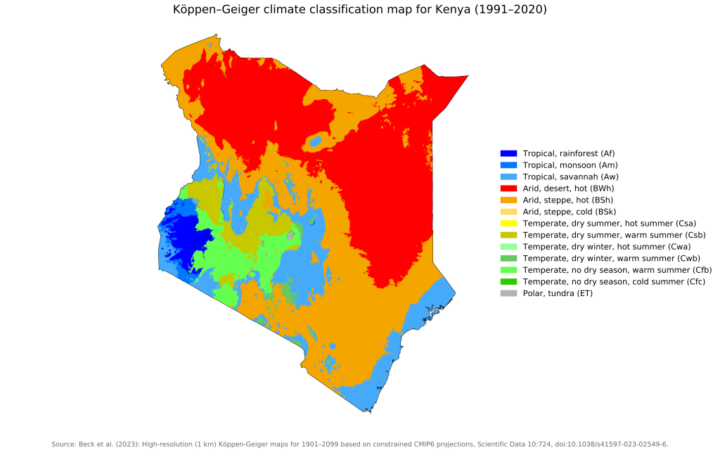
Kenya’s climate varies significantly from region to region. Coastal areas like Mombasa and Lamu experience a tropical climate, with high humidity and rainfall throughout the year. In contrast, the inland regions, particularly in the Rift Valley and northern Kenya, experience more arid conditions, with substantial temperature fluctuations between day and night.
The country has two rainy seasons: the long rains from March to May and the short rains from October to December. The climate is impacted by Kenya’s elevation, with cooler temperatures found in the highlands compared to the lowlands.
Natural Resources and Land Use
Kenya is rich in natural resources, including minerals such as limestone, soda ash, salt, and titanium, as well as gemstones and fluorite. The country also boasts significant agricultural resources, with fertile soil supporting the cultivation of tea, coffee, maize, and horticultural products. However, much of Kenya’s land is categorized as permanent pasture, with about 9.8% designated as arable land.
In terms of land use, Kenya is known for its wildlife, which forms the basis for its renowned tourism industry. The country’s national parks, such as the Maasai Mara and Amboseli, are crucial for conservation and biodiversity. Additionally, Kenya is home to several forest reserves, including Mau Forest, which is the largest forest complex in East Africa.
Environmental Concerns and Climate Change
Like many African countries, Kenya faces environmental challenges, including deforestation, water pollution, soil erosion, and the threat of desertification. The impacts of climate change are becoming increasingly evident, with more frequent droughts, flooding, and shifting rainfall patterns affecting agriculture, water security, and infrastructure.
The rise in global temperatures and erratic weather patterns, particularly in Arid and Semi-Arid Lands (ASALs), is exacerbating food insecurity and creating more pressure on marginalized communities. Coastal areas also face the threat of sea-level rise, leading to saltwater intrusion into freshwater resources.
Natural Hazards
Kenya is prone to natural hazards such as drought and flooding during the rainy seasons. These extreme weather events not only disrupt livelihoods but also place significant strain on the country’s agricultural production. While volcanic activity in Kenya is limited, there are a few active volcanoes, such as Mount Longonot, which pose risks to nearby communities.
Conclusion
Kenya’s diverse geography, ranging from coastal plains to highland plateaus, is integral to the country’s identity. Its varied climate, water resources, and natural features offer both challenges and opportunities. The ongoing impacts of climate change require proactive measures to protect the environment and sustain Kenya’s development for future generations.